Abbey Falls
Comprehensive visitor guide to Abbey Falls (Abbi Falls) near Madikeri, Coorg. Details on hanging bridge viewpoint, coffee plantations, timings, and road route.
Location
Coorg & Chikmagalur, Karnataka
A closer look
Your visit, at a glance.
Coorg Chikmagalur, Karnataka
GET TO KNOW THE PLACE
Nestled within the emerald embrace of private coffee and spice plantations in the misty highlands of Kodagu (Coorg), Abbey Falls - known natively in Kodava Takk and Kannada as…
The story of Abbey Falls
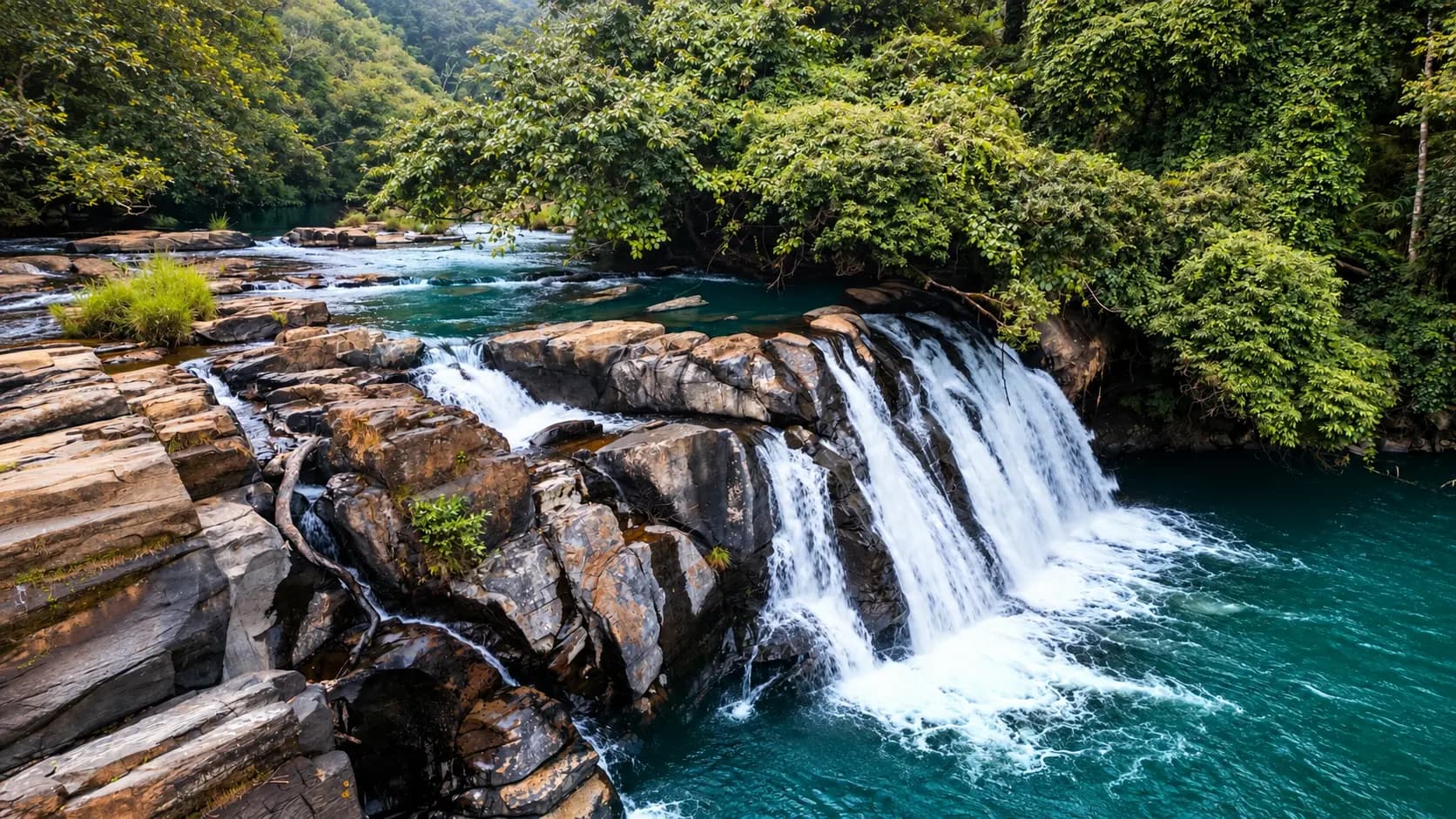
Nestled within the emerald embrace of private coffee and spice plantations in the misty highlands of Kodagu (Coorg), Abbey Falls - known natively in Kodava Takk and Kannada as Abbi Falls - is one of the most celebrated and visually arresting natural landmarks in the Western Ghats. Located in Madikeri Taluk of Kodagu District in southern Karnataka, approximately 8 to 10 kilometers northwest of the district headquarters at Madikeri, this roaring cascade sits at an elevation of 1,070 meters (3,510 feet) above mean sea level. Plunging over 21 meters (70 feet) across massive, stepped basaltic granite boulders into a turbulent mountain gorge, Abbey Falls combines thunderous aquatic power, lush plantation biodiversity, and fascinating colonial heritage into an quintessential Coorg experience.
Start here. Open a tile for the full details.
Why goRead details
Few sights in southern Karnataka encapsulate the romantic, rain-drenched spirit of Coorg quite like the journey to Abbey Falls. Long before the falls come into view, visitors can hear the deep, resonant acoustic roar of rushing water reverberating through the dense forest canopy. The approach to the waterfall is an enchanting sensory experience in its own right: a shaded paved pathway winds down through an authentic, working coffee plantation, where glossy green Arabica and Robusta bushes are interspersed with creeping vines of black pepper (Piper nigrum) twining high around silver oak shade trees, aromatic cardamom shrubs, and giant wild tree ferns. The rich, earthy fragrance of damp fertile soil, crushed coffee leaves, and forest moss fills the cool mountain air.
When to visitRead details
Entry & permissionsRead details
Fees, visiting hours and entry rules may change. Confirm the latest details with the official operator or local authority before travelling.
Abbey Falls is managed through a collaborative partnership between the local plantation owners, the Tourism Development Committee of Kodagu, and the District Administration of Kodagu.
+----------------------------------------------------------------------------------------------------+
|                                    ADMISSION AND TIMINGS SUMMARY                                   |
|                                                                                                    |
|  [OPERATING HOURS]                                                                                 |
|  - Daily Timings: 09:00 AM to 17:00 (5:00 PM).                                                     |
|  - Ticket Booth Closing: Promptly at 16:30. Visitors must begin ascending by 17:00.                |
|  - Open Days: Monday through Sunday (365 days a year, subject to extreme weather flood closures).  |
|                                                                                                    |
|  [ENTRANCE TARIFFS]                                                                                |
|  - Adult Visitors (Aged 3 and above): ₹15 per person.                                              |
|  - Infants (Below 3 years): Free entry.                                                            |
|                                                                                                    |
|  [VEHICULAR PARKING CHARGES]                                                                       |
|  - Four-Wheelers (Cars, Jeeps, SUVs): ₹50 per vehicle.                                             |
|  - Two-Wheelers (Motorcycles, Scooters): ₹20 per vehicle.                                          |
|  - Tourist Tempo Travelers & Minibuses: ₹100 per vehicle.                                          |
|                                                                                                    |
|  [SAFETY & STATUTORY RESTRICTIONS]                                                                 |
|  - Bathing & Swimming: STRICTLY PROHIBITED; punishable with fines.                                 |
|  - Safety Fence: Crossing safety barricades or climbing boulders is strictly illegal.              |
|  - Drones & Filming: Drones prohibited without prior district police and estate clearance.         |
|  - Environment: Strictly plastic-free and alcohol-free zone; smoking prohibited.                   |
+----------------------------------------------------------------------------------------------------+
Safety Rules and Water Ban Enforcement
The Kodagu District Administration strictly enforces a complete ban on entering the water at Abbey Falls. Multiple warning boards in English, Kannada, and Hindi are posted along the railings. Security personnel are stationed on the esplanade to monitor visitor conduct.
- Never attempt to climb over the chain-link barricades or scramble across the granite boulders below the bridge. The rocks are coated in invisible, slick algae that offers zero friction.
- Avoid leaning excessively over the bridge railings to take selfies. Keep smartphones and cameras secured with wrist or neck straps.
Monsoon Leech Precautions
If you are visiting Abbey Falls during the wet monsoon season (June to September) or the immediate post-monsoon period (October), you will likely encounter terrestrial land leeches (Haemadipsa). These harmless but annoying parasites thrive in the damp leaf litter and grass beside the concrete pathway:
- Stick strictly to the paved concrete and stone steps; avoid walking onto wet soil, grass verges, or brushing against low-hanging shrubs.
- Wear closed walking shoes with high socks pulled up over your trouser cuffs.
- Applying a little salt, eucalyptus oil, or mosquito repellent (DEET) to your footwear and lower socks before starting down the steps acts as an effective natural deterrent.
Plan your visitRead details
Abbey Falls is conveniently located just 8 to 10 kilometers northwest of Madikeri, the central hill station town and administrative capital of Kodagu District.
Explore the full guide - choose a topic below.
Why visit?
Few sights in southern Karnataka encapsulate the romantic, rain-drenched spirit of Coorg quite like the journey…Explore detailsClose details
Few sights in southern Karnataka encapsulate the romantic, rain-drenched spirit of Coorg quite like the journey to Abbey Falls. Long before the falls come into view, visitors can hear the deep, resonant acoustic roar of rushing water reverberating through the dense forest canopy. The approach to the waterfall is an enchanting sensory experience in its own right: a shaded paved pathway winds down through an authentic, working coffee plantation, where glossy green Arabica and Robusta bushes are interspersed with creeping vines of black pepper (Piper nigrum) twining high around silver oak shade trees, aromatic cardamom shrubs, and giant wild tree ferns. The rich, earthy fragrance of damp fertile soil, crushed coffee leaves, and forest moss fills the cool mountain air.
At the base of the trail, the dense foliage suddenly opens to reveal a dramatic, sheer mountain gorge. Here, mountain streams born in the high rainforest ridges of the Western Ghats converge and cascade down a 21-meter (70-foot) vertical precipice. The torrent splits and crashes across multiple tiers of dark, water-worn granite boulders, churning into a frothing, roaring curtain of white water before collecting in a deep plunge pool that flows onward through boulder-strewn rapids to merge with the sacred Cauvery (Kaveri) River.
Directly facing the waterfall across the chasm hangs a sturdy suspension footbridge (hanging bridge). Standing upon this swaying vantage point suspended high above the frothing gorge, visitors enjoy an exhilarating, head-on panoramic view of the falls. A delicate, refreshing cloud of fine mist drifts continuously across the bridge, cooling your skin and catching the shafts of sunlight that filter through the canopy to create shimmering miniature rainbows.
Steeped in local history, the waterfall was known during British colonial times as Jessy Falls, christened in the 1830s by the first British chaplain of Coorg in memory of his daughter or wife. Later restored to its indigenous Kodava nomenclature - derived from Abbi, meaning "falls" or "cascade" - Abbey Falls offers an accessible, visually stunning encounter with the wild hydrological soul of Karnataka's coffee heartland.
What to expect
Visiting Abbey Falls is a multi-layered sensory excursion that requires approximately one and a half to two hours.Explore detailsClose details
Visiting Abbey Falls is a multi-layered sensory excursion that requires approximately one and a half to two hours. The experience encompasses a scenic mountain drive through the hills of Madikeri, a pleasant downhill walk through lush spice estates, an exhilarating view from the hanging bridge, and a moderately steep climb back up to the roadhead.
+----------------------------------------------------------------------------------------------------+
|                                    ABBEY FALLS SITE PRECINCT MAP                                   |
|                                                                                                    |
|  [Roadhead & Vehicular Parking Terminal: 1,120 m Elevation]                                        |
|  - Pay-and-park lot for cars, SUVs, two-wheelers. Ticket counter and security gate.                |
|  - Spices, pure honey, homemade chocolates, and filter coffee stalls.                              |
|                                                  |                                                 |
|                                                  v                                                 |
|  ============================== [COFFEE ESTATE DESCENT (500 METERS)] ============================= |
|  - Approx. 200 paved concrete & stone steps winding down through plantation.                       |
|  - Lined with steel handrails, Robusta coffee bushes, pepper vines, and tall silver oaks.          |
|  - Shaded by dense rainforest canopy; gentle mountain birdsong.                                    |
|                                                  |                                                 |
|                                                  v                                                 |
|  ============================== [GORGE PLATFORM & HANGING BRIDGE] ================================ |
|  - Steel suspension footbridge hanging directly opposite the cascade.                              |
|  - Unobstructed head-on viewing platform over the roaring 21-meter waterfall.                      |
|  - Small Sri Kali Mata temple shrine perched on the stone riverbank.                               |
|                                                  |                                                 |
|                                                  v                                                 |
|  ============================== [THE CASCADE & PLUNGE POOL] ====================================== |
|  - 21-meter vertical drop over stepped black granite boulders.                                     |
|  - Deep, turbulent plunge pool with strong undertows and submerged rocks.                         |
|  - STRICTLY BARRICADED: Water entry, bathing, and swimming are strictly prohibited.                |
+----------------------------------------------------------------------------------------------------+
The Plantation Descent: 200 Steps Through Coffee and Spices
The journey begins at the hilltop roadhead parking terminal along the Madikeri-Galibeedu road. After passing the official ticket booth, visitors enter a private pedestrian entrance leading into the lush estate of the Neravanda family, who cleared and cultivated these slopes following Indian independence.
The pathway descends roughly 500 meters through the heart of a mature coffee and spice plantation via approximately 200 concrete and stone steps. As you descend beneath the dense canopy of silver oak and wild jackfruit trees, notice the classic multi-tiered agroforestry architecture of Coorg:
- Upper Canopy: Towering silver oaks (Grevillea robusta) provide dappled shade to protect delicate coffee shrubs from intense solar radiation.
- Mid-Tier Vines: The trunk of almost every shade tree is wrapped in thick, emerald vines of black pepper (Piper nigrum), with drooping clusters of green pepper berries ripening in the humid air.
- Understory: Lush bushes of high-grade Arabica and Robusta coffee, laden with fragrant white blossoms in early spring or glossy red "cherries" in winter.
- Ground Floor: Aromatic cardamom plants (Elettaria cardamomum) with broad, fragrant leaves, medicinal wild ginger, and delicate ferns springing from moss-covered granite boulders.
The path is equipped with sturdy steel railings. While descending is effortless and scenic, visitors should keep in mind that returning to the parking lot requires climbing back up these 200 steps - a moderately strenuous cardiovascular workout that takes 15 to 20 minutes at a steady pace.
The Suspension Hanging Bridge
At the base of the plantation trail, the path terminates at a wide viewing esplanade and a dedicated pedestrian suspension footbridge (hanging bridge) constructed across the river gorge. Suspended by heavy steel cables anchored into the rock faces on either bank, the bridge hangs directly opposite the thundering curtain of Abbey Falls, roughly 30 meters downstream from the main drop.
Standing on the bridge offers an unmatched perspective:
- You are positioned dead-center in front of the waterfall, watching millions of liters of white water plunge over the black basalt ledge and shatter across the lower boulders.
- The roar of the water drowns out all human conversation, vibrating through your chest and filling the gorge with a continuous acoustic rumble.
- Cool spray and mist billow outward, creating a perpetual natural air conditioner. On sunny mornings between 09:30 and 11:30, sunlight angles through the mist to cast vibrant miniature rainbows across the plunge pool.
- Due to structural safety and crowd control regulations, security personnel often regulate the number of visitors permitted on the hanging bridge simultaneously during peak holiday weekends, preventing excessive swaying.
The Sacred Kali Temple and Riverbed Ecology
Perched on a raised stone outcrop near the western end of the footbridge sits a small, rustic shrine dedicated to Sri Kali Mata. Local plantation workers and Kodava elders pause here to light incense, offer flowers, and ring the brass temple bell before beginning their daily work.
Downstream from the footbridge, the churning plunge pool narrows into a boulder-strewn mountain stream. The clear, oxygen-rich waters flow swiftly through dense bamboo thickets and riparian forest for several kilometers before eventually emptying into the upper reaches of the sacred Cauvery River. The surrounding damp rocks support a rich biodiversity of amphibians, including endemic Western Ghats bush frogs (Raorchestes) and torrent frogs, whose rhythmic chirping echoes through the gorge at twilight.
Strict Safety Barricades and Water Prohibitions
It is critical for all visitors to understand that bathing, swimming, wading, and stepping down to the water's edge are strictly banned at Abbey Falls. In earlier decades, before the installation of tall chain-link safety barricades and warning signboards by the Kodagu District Administration, numerous tragic drowning accidents occurred here.
The plunge pool beneath the falls is deceptive: what appears on the surface to be calm, shallow water is in reality a turbulent vortex reaching depths of several meters, concealing jagged submerged rocks, treacherous slippery moss, and powerful undertows that can pull even experienced swimmers under. Sturdy steel barricades run the entire length of the viewing area, and security guards are stationed along the platform to enforce the ban. Enjoy the magnificent spectacle from the safety of the bridge and paved viewing decks.
Best time to visit
The appearance and character of Abbey Falls vary dramatically across the seasons, dictated by the powerful…Explore detailsClose details
Seasonal Water Volumes and Microclimate
The appearance and character of Abbey Falls vary dramatically across the seasons, dictated by the powerful rhythms of the southwest monsoon over the Western Ghats:
+----------------------------------------------------------------------------------------------------+
|                                    SEASONAL VISITING & WATERFALL VOLUME GUIDE                      |
|                                                                                                    |
|  [JULY TO SEPTEMBER: PEAK MONSOON ROAR]                                                            |
|  - Water Volume: Colossal, thunderous torrent; water turns coffee-cream brown from mountain mud.   |
|  - Environment: High humidity, cool rains (18°C to 22°C), hanging bridge soaked in heavy spray.    |
|  - Experience: Absolute peak power and awe; forest is intensely green and alive.                   |
|  - Hazards: Slippery concrete steps; active land leeches in plantation grass; rain gear essential. |
|                                                                                                    |
|  [OCTOBER TO JANUARY: POST-MONSOON SWEET SPOT (RECOMMENDED)]                                       |
|  - Water Volume: Substantial, roaring flow; water runs crystal-clear and frothy white.             |
|  - Environment: Crisp, sunny, pleasant highland weather (16°C to 26°C); minimal rain.              |
|  - Experience: The absolute best overall visitor window - great photography, dry steps, clear spray. |
|                                                                                                    |
|  [FEBRUARY TO MAY: DRY SUMMER]                                                                     |
|  - Water Volume: Flow reduces to several narrow ribbons cascading over exposed black boulders.     |
|  - Environment: Warm daytime sunshine (22°C to 33°C); mornings and evenings remain cool.           |
|  - Experience: Peaceful, uncrowded; plantation walk is pleasant, but waterfall lacks thunder.      |
+----------------------------------------------------------------------------------------------------+
The Ideal Time of Day
- Morning Arrival (09:00 AM to 10:30 AM): Check the current visiting hours and permitted access with the site operator before departure; ceremonies, closures and visitor sessions can affect access. You avoid the mid-day heat during the 200-step uphill climb, experience the plantation at its coolest, secure uncrowded photos on the hanging bridge, and enjoy easy vehicle parking before the large tourist coaches arrive from Bengaluru and Mysuru.
- Avoid Peak Holiday Mid-Days: Check the current visiting hours and permitted access with the site operator before departure; ceremonies, closures and visitor sessions can affect access.
How to reach
Abbey Falls is conveniently located just 8 to 10 kilometers northwest of Madikeri, the central hill station town…Explore detailsClose details
Abbey Falls is conveniently located just 8 to 10 kilometers northwest of Madikeri, the central hill station town and administrative capital of Kodagu District.
+----------------------------------------------------------------------------------------------------+
|                                      REGIONAL TRANSIT CONNECTIONS                                  |
|                                                                                                    |
|  [Kannur International Airport (CNN): 95 km SW]    <--- Virajpet-Madikeri Road (approx. 2.5 hrs)   |
|  [Mangaluru International Airport (IXE): 145 km W] <--- Sampaje Ghat & NH-275 (approx. 3.5 hrs)   |
|  [Kempegowda Int'l Airport (BLR): 290 km E]        <--- Bengaluru-Mysuru Expressway (approx. 5 hrs)|
|                                                                                                    |
|                                                  |                                                 |
|                                                  v                                                 |
|  ============================== [MADIKERI TOWN / KSRTC BUS STAND] ================================= |
|  - District headquarters; central transport hub with hotels, homestays, and taxi stands.          |
|  - Frequent KSRTC buses from Bengaluru (Satellite Bus Stand), Mysuru, and Mangaluru.               |
|                                                  |                                                 |
|                                                  v                                                 |
|  ============================== [GALIBEEDU ROAD TO ABBEY FALLS (8 KM)] ============================ |
|  - Narrow, scenic two-lane paved mountain road through rolling coffee estates.                     |
|  - 20-minute drive by private car, hired taxi, or local auto-rickshaw.                             |
|                                                  |                                                 |
|                                                  v                                                 |
|  ============================== [ABBEY FALLS ROADHEAD PARKING TERMINAL] =========================== |
|  - Pay-and-park lot; ticket booth; entrance gate to 200-step plantation trail.                     |
+----------------------------------------------------------------------------------------------------+
By Road from Madikeri Town (8 km)
From central Madikeri (Raja's Seat or the General K.S. Thimayya Circle), follow the signs heading northwest toward Galibeedu. The road winds through undulating coffee country, flanked by tall silver oaks and quaint Kodava farmhouses. The drive takes approximately 20 to 25 minutes:
- By Taxi / Auto-Rickshaw: Auto-rickshaws and tourist taxis are readily available at the Madikeri Bus Stand and Raja's Seat auto stand. Confirm the current charge and what it includes with the operator or service provider. Visitor admission, vehicles, parking, activities and accommodation can have separate charges.
- By Self-Drive Car / Motorcycle: The road is fully paved with tarmac but is relatively narrow in several sections, with blind curves and drainage ditches. Drive carefully, maintain low speeds (under 35 km/h), and yield to oncoming vehicles at narrow road shoulders.
Regional Road Connectivity to Madikeri
- From Mysuru (125 km): Drive west along National Highway 275 past Hunsur, Kushalnagar, and Suntikoppa. The well-maintained four-lane and two-lane highway reaches Madikeri in approximately 2.5 to 3 hours.
- From Bengaluru (260 km): Take the 10-lane Bengaluru-Mysuru Expressway (NH-275) to Srirangapatna/Mysuru (approx. 90 minutes), then continue westward along NH-275 through Hunsur and Kushalnagar to Madikeri. Total driving time is roughly 4.5 to 5.5 hours.
- From Mangaluru (140 km): Ascend through the scenic Western Ghats via the Sampaje Ghat (NH-275) past Bantwal, Puttur, and Sullia, arriving in Madikeri in about 3.5 hours.
Nearest Railway Stations
Kodagu District has no rail connectivity due to its steep mountainous Western Ghats topography. The most convenient railheads are:
- Mysuru Junction (MYS): 125 km east, offering frequent superfast, Vande Bharat, and Shatabdi trains to Bengaluru, Chennai, and Hyderabad. Direct KSRTC express buses connect Mysuru railway station to Madikeri every 20 minutes.
- Hassan Junction (HAS): 115 km north, connected to Bengaluru and northern Karnataka.
- Mangaluru Central (MAQ): 140 km west, offering coastal rail connectivity to Goa, Mumbai, and Kerala.
Nearest Airports
- Kannur International Airport (CNN), Kerala: Situated approximately 95 km southwest, Kannur is the closest commercial airport to Coorg. Taxis from Kannur reach Madikeri via Virajpet in approximately 2.5 hours.
- Mangaluru International Airport (IXE): Located 145 km west, with regular domestic flights and Middle Eastern connections (approx. 3.5 to 4 hours by road).
- Kempegowda International Airport Bengaluru (BLR): 290 km east, with direct KSRTC Flybus connectivity to Mysuru, where simple bus transfers connect to Madikeri.
Entry, timings and permissions
Fees, visiting hours and entry rules may change.Explore detailsClose details
Fees, visiting hours and entry rules may change. Confirm the latest details with the official operator or local authority before travelling.
Abbey Falls is managed through a collaborative partnership between the local plantation owners, the Tourism Development Committee of Kodagu, and the District Administration of Kodagu.
+----------------------------------------------------------------------------------------------------+
|                                    ADMISSION AND TIMINGS SUMMARY                                   |
|                                                                                                    |
|  [OPERATING HOURS]                                                                                 |
|  - Daily Timings: 09:00 AM to 17:00 (5:00 PM).                                                     |
|  - Ticket Booth Closing: Promptly at 16:30. Visitors must begin ascending by 17:00.                |
|  - Open Days: Monday through Sunday (365 days a year, subject to extreme weather flood closures).  |
|                                                                                                    |
|  [ENTRANCE TARIFFS]                                                                                |
|  - Adult Visitors (Aged 3 and above): ₹15 per person.                                              |
|  - Infants (Below 3 years): Free entry.                                                            |
|                                                                                                    |
|  [VEHICULAR PARKING CHARGES]                                                                       |
|  - Four-Wheelers (Cars, Jeeps, SUVs): ₹50 per vehicle.                                             |
|  - Two-Wheelers (Motorcycles, Scooters): ₹20 per vehicle.                                          |
|  - Tourist Tempo Travelers & Minibuses: ₹100 per vehicle.                                          |
|                                                                                                    |
|  [SAFETY & STATUTORY RESTRICTIONS]                                                                 |
|  - Bathing & Swimming: STRICTLY PROHIBITED; punishable with fines.                                 |
|  - Safety Fence: Crossing safety barricades or climbing boulders is strictly illegal.              |
|  - Drones & Filming: Drones prohibited without prior district police and estate clearance.         |
|  - Environment: Strictly plastic-free and alcohol-free zone; smoking prohibited.                   |
+----------------------------------------------------------------------------------------------------+
Safety Rules and Water Ban Enforcement
The Kodagu District Administration strictly enforces a complete ban on entering the water at Abbey Falls. Multiple warning boards in English, Kannada, and Hindi are posted along the railings. Security personnel are stationed on the esplanade to monitor visitor conduct.
- Never attempt to climb over the chain-link barricades or scramble across the granite boulders below the bridge. The rocks are coated in invisible, slick algae that offers zero friction.
- Avoid leaning excessively over the bridge railings to take selfies. Keep smartphones and cameras secured with wrist or neck straps.
Monsoon Leech Precautions
If you are visiting Abbey Falls during the wet monsoon season (June to September) or the immediate post-monsoon period (October), you will likely encounter terrestrial land leeches (Haemadipsa). These harmless but annoying parasites thrive in the damp leaf litter and grass beside the concrete pathway:
- Stick strictly to the paved concrete and stone steps; avoid walking onto wet soil, grass verges, or brushing against low-hanging shrubs.
- Wear closed walking shoes with high socks pulled up over your trouser cuffs.
- Applying a little salt, eucalyptus oil, or mosquito repellent (DEET) to your footwear and lower socks before starting down the steps acts as an effective natural deterrent.
Nearby places to consider
Abbey Falls sits just minutes away from Madikeri's most iconic historical monuments, cultural viewpoints, and…Explore detailsClose details
Abbey Falls sits just minutes away from Madikeri's most iconic historical monuments, cultural viewpoints, and scenic mountain ridges.
+----------------------------------------------------------------------------------------------------+
|                                    NEARBY DESTINATIONS NETWORK                                     |
|                                                                                                    |
|  [Mandalpatti Peak: 18 km North]                 [Gaddige (Raja's Tombs): 9 km Southeast]         |
|  (Misty 4x4 Jeep Ridge, Sweeping Valley Views)   (1820 Indo-Saracenic Royal Mausoleums)            |
|         ^                                              ^                                           |
|          \                                            /                                            |
|           \                                          /                                             |
|  ================== [ABBEY FALLS (ABBI FALLS): 21 M WATERFALL GORGE] =============================== |
|           /                                          \                                             |
|          /                                            \                                            |
|         v                                              v                                           |
|  [Madikeri Fort: 8 km South]                     [Raja's Seat: 9 km South]                         |
|  (17th-Century Citadel, Palace & Museum)         (Historic Royal Sunset Pavilion & Floral Gardens) |
+----------------------------------------------------------------------------------------------------+
Raja's Seat (9 km South)
Perched atop a high cliff edge in southern Madikeri, Raja’s Seat ("Seat of the King") was the favored evening retreat of the Kodava kings, who came here accompanied by their queens to watch the sunset over the Western Ghats. Set amidst beautifully landscaped seasonal flower gardens, musical fountains, and a toy train for children, the historic brick-and-mortar arched pavilion offers breathtaking panoramic vistas over deep green valleys, winding roads, and distant forested ridges fading into purple twilight mist.
Madikeri Fort and Palace (8 km South)
Dominating the center of Madikeri town, Madikeri Fort was originally constructed of mud in the late 17th century by Mudduraja, the founder of the town, and was later rebuilt in solid granite by Tipu Sultan, who renamed it Jaffarabad. After the British annexed Coorg in 1834, they added a handsome clock tower, administrative offices, and an Anglican church (St. Mark's Church, which now houses an Archaeological Museum exhibiting Kodava royal weaponry, statues, and historical photographs). Guarding the entrance to the inner palace courtyard are two life-sized mortar sculptures of royal elephants.
Gaddige / Raja's Tombs (9 km Southeast)
Located in the northern quarter of Madikeri, Gaddige features three striking royal mausoleums dating back to the early 19th century, housing the mortal remains of King Doddavirarajendra, his queen Mahadeviamma, and King Lingarajendra II. Architecturally fascinating, these tombs were built in the Indo-Saracenic style with bulbous Islamic-style domes and minarets crowned by brass kalasas, but adorned with carved figures of Nandi bulls and Hindu deities along the cornices.
Mandalpatti Peak (18 km North)
Rising to an elevation of approximately 1,600 meters in the Pushpagiri wildlife range north of Madikeri, Mandalpatti (meaning "Market of Clouds") is one of Coorg's most exhilarating high-altitude viewpoints. Reachable only by hired 4x4 four-wheel-drive jeeps navigating rugged, boulder-strewn dirt tracks through lush shola forests and grasslands, Mandalpatti offers 360-degree views across endless green ridges shrouded in swirling mist.
In pictures
The practical bits
Before you go.
Plan ahead
Thoughtful preparation will ensure your excursion to Abbey Falls is comfortable, scenic, and properly integrated…Explore detailsClose details
Thoughtful preparation will ensure your excursion to Abbey Falls is comfortable, scenic, and properly integrated into your broader Coorg exploration.
Wear Sturdy Walking Footwear with Reliable Grip
While the entire 500-meter trail is paved with concrete steps, frequent mountain rains and morning mist can make…Explore detailsClose details
While the entire 500-meter trail is paved with concrete steps, frequent mountain rains and morning mist can make stone surfaces slick. Wear sturdy walking sneakers or trekking shoes with rubber treads. Avoid smooth-soled leather shoes, high heels, or slippery flip-flops.
Pace Yourself on the 200-Step Uphill Climb
Walking down through the cool coffee estate to the waterfall takes roughly 7 to 10 minutes and requires little…Explore detailsClose details
Walking down through the cool coffee estate to the waterfall takes roughly 7 to 10 minutes and requires little effort. However, returning to the parking lot requires climbing approximately 200 continuous steps. Take your time, use the shaded resting benches installed at intermediate switchbacks, and keep a bottle of drinking water on hand.
Bring Cash for Parking and Local Plantation Stalls
While digital UPI payments are increasingly accepted at the main ticket counter, mobile network connectivity can…Explore detailsClose details
While digital UPI payments are increasingly accepted at the main ticket counter, mobile network connectivity can be spotty in the forested gorge. Confirm the current charge and what it includes with the operator or service provider. Visitor admission, vehicles, parking, activities and accommodation can have separate charges.
Shop for Fresh Farm Produce at the Roadhead
The stalls outside the parking terminal are operated by local planters and cooperatives, offering excellent…Explore detailsClose details
The stalls outside the parking terminal are operated by local planters and cooperatives, offering excellent prices on farm-fresh Coorg goods: whole black pepper, green cardamom pods, cinnamon bark, pure raw honey, estate-roasted coffee beans, homemade chocolates, and traditional Coorg fruit wines.
Combine with Madikeri Heritage Circuit
Because a thorough visit to Abbey Falls takes roughly two hours, it pairs perfectly with a full day of…Explore detailsClose details
Because a thorough visit to Abbey Falls takes roughly two hours, it pairs perfectly with a full day of sightseeing around Madikeri town. Combine the waterfall with visits to the historic Madikeri Fort & Palace, the panoramic sunset overlook at Raja’s Seat, and the sacred tomb complex of Gaddige (Raja’s Tomb).
+----------------------------------------------------------------------------------------------------+
|                                  SUGGESTED COMBINED DAY ITINERARY: MADIKERI HIGHLANDS              |
|                                                                                                    |
|  08:30 AM to 09:15 AM  -  Scenic Morning Drive to Abbey Falls                                        |
|  - Depart Madikeri via Galibeedu Road; enjoy scenic coffee estate views.                           |
|  - Arrive at roadhead parking terminal before morning tourist rush.                                |
|                                                                                                    |
|  09:15 AM to 11:00 AM  -  Abbey Falls & Spice Plantation Walk                                        |
|  - Descend 200 steps through lush Arabica and Robusta bushes with pepper vines.                   |
|  - Stand on the hanging footbridge; marvel at the roaring 21-meter cascade and morning mist.       |
|  - Visit the rustic Kali Mata shrine; ascend leisurely back to parking terminal.                   |
|                                                                                                    |
|  11:15 AM to 11:45 AM  -  Estate Spice & Coffee Shopping                                            |
|  - Browse local stalls for whole black pepper, cardamom, pure Coorg honey, and coffee beans.       |
|                                                                                                    |
|  12:15 PM to 01:45 PM  -  Authentic Kodava Lunch in Madikeri                                         |
|  - Savor traditional Coorg delicacies at a local heritage restaurant: *Akki Roti*, fragrant       |
|    vegetable curry, or the famous spiced *Kadamputtu* (steamed rice dumplings).                   |
|                                                                                                    |
|  02:15 PM to 03:45 PM  -  Madikeri Fort, Palace & Museum                                             |
|  - Tour the 17th-century granite fort founded by Mudduraja; inspect the stone elephant statues.    |
|  - Visit the Mahatma Gandhi Public Library and the archaeological museum inside the fort.          |
|                                                                                                    |
|  04:15 PM to 05:00 PM  -  Gaddige (Raja's Tombs)                                                     |
|  - Admire the Indo-Saracenic domed mausoleums of the Kodagu kings overlooking the hills.           |
|                                                                                                    |
|  05:30 PM to 06:45 PM  -  Sunset at Raja's Seat                                                      |
|  - Stroll through seasonal flower gardens to the historic stone pavilion used by Kodagu kings.     |
|  - Watch the golden sun sink into the layered blue ridges of the Western Ghats.                    |
+----------------------------------------------------------------------------------------------------+
A few things you might wonder
Common questions about visiting Abbey Falls. Fees, visiting hours and ceremonies are researched details that may change; confirm current arrangements with the operator before travelling.
Is swimming or bathing allowed at Abbey Falls?
How many steps must visitors walk to reach Abbey Falls?
Is Abbey Falls wheelchair accessible?
What is the best season to visit Abbey Falls?
How far is Abbey Falls from Madikeri town?
Why was the waterfall formerly called Jessy Falls?
Are there leeches on the pathway to Abbey Falls?
What are the opening hours and ticket costs?
Explore more in Coorg Chikmagalur
Discover other destinations around this hub
More Hubs in Karnataka
Continue exploring other travel hubs in this state
Planning a trip to Coorg Chikmagalur?