Kothapally Waterfalls
Discover Kothapally Waterfalls in Alluri Sitharama Raju district, Andhra Pradesh. Complete travel guide covering timings, entry fees, trekking steps, and route.
Location
Eastern Ghats, Andhra Pradesh
A closer look
Your visit, at a glance.
Eastern Ghats, Andhra Pradesh
GET TO KNOW THE PLACE
Hidden amidst the undulating forested ridges and coffee-carpeted valleys of the Eastern Ghats in Andhra Pradesh, Kothapally Waterfalls is one of the most charming and refreshing…
The story of Kothapally Waterfalls
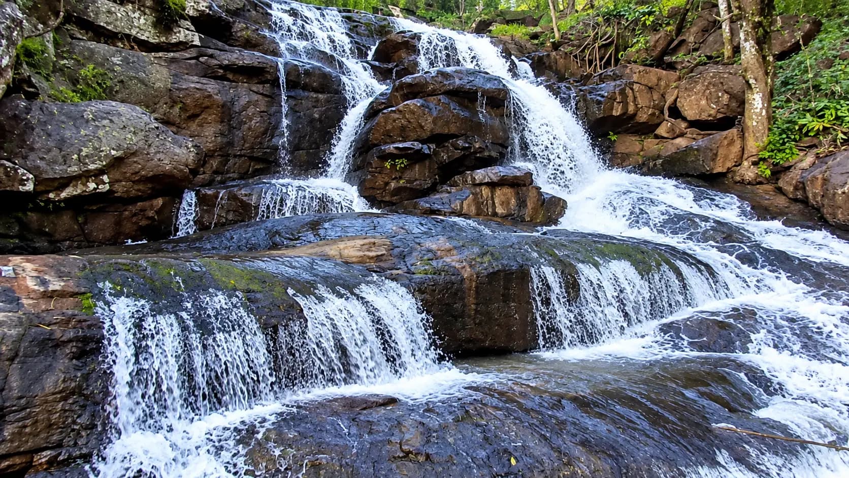
Hidden amidst the undulating forested ridges and coffee-carpeted valleys of the Eastern Ghats in Andhra Pradesh, Kothapally Waterfalls is one of the most charming and refreshing natural attractions in the agency highlands. Located near Kothapally village within Gangaraju Madugula (G. Madugula) Mandal in the Alluri Sitharama Raju (ASR) District, this scenic cascade sits at an altitude of approximately 920 metres (3,018 feet) above mean sea level. Unlike single-drop waterfalls that plunge vertically into inaccessible chasms, Kothapally cascades across a sequence of stepped, dark metamorphic rock terraces spanning 25 to 30 metres in width. The foaming streams spread broadly across the rock ledges before gathering into a calm, pebble-and-cobblestone splash pool that welcomes wading and peaceful contemplation.
What elevates Kothapally Waterfalls beyond its picturesque geological setting is its remarkable background of community-driven eco-development. Until 2012, this forest cascade remained largely hidden from outside travellers, known only to local tribal herders. When a local schoolboy named Vanthala Abbi stumbled upon the falls and alerted village elders, the indigenous community partnered with the Integrated Tribal Development Agency (ITDA) at Paderu to clear overgrown underbrush and construct stone and concrete staircases down the steep hillside. Today, Kothapally is managed collaboratively by a local tribal youth committee, ensuring that entry fees directly support village sanitation, trail maintenance, and indigenous livelihoods while offering travellers an authentic eco-tourism retreat.
Start here. Open a tile for the full details.
Why goRead details
- Scenic Multi-Tiered Cascades: Marvel at a broad, terraced waterfall that tumbles gracefully across stepped granite ledges, creating shimmering ribbons of white foam against dark highland stone.
- Cool Highland Microclimate: Perched at 920 metres above sea level, the waterfall gorge provides a cool, rejuvenating escape from the hot and humid coastal plains of Andhra Pradesh.
- Lush Coffee and Pepper Plantations: Walk past shaded organic Arabica coffee groves and fragrant black pepper vines clinging to towering silver oak and jackfruit trees.
- Inspiring Community Conservation: Experience a destination lovingly maintained by local tribal youth, where nominal entry fees go directly toward community welfare and trail upkeep.
- Safe, Shallow Wading Basins: Enjoy wading in clear, cool hill-stream waters along a wide, gravelly pool framed by giant boulders and wild river ferns.
- Seamless Eastern Ghats Road Trip Circuit: Conveniently located just 30 kilometres from Paderu and 40 kilometres from mist-cloaked Lambasingi, making it an ideal stop on regional weekend itineraries.
When to visitRead details
The post-monsoon and winter months from October through February represent the ideal window for visiting Kothapally Waterfalls. During this timeframe, the monsoon rains have filled the upper forest aquifer, ensuring a robust, photogenic sheet of water tumbling over the dark rocks without the hazardous churning turbulence seen during July and August cloudbursts. Furthermore, winter morning temperatures on the G. Madugula plateau frequently drop to around 10°C to 14°C, wrapping the winding coffee-fringed roads in romantic morning mist and providing perfect hiking conditions.
Entry & permissionsRead details
Fees, visiting hours and entry rules may change. Confirm the latest details with the official operator or local authority before travelling.
Entry Tariffs and Operational Timings
Item | Tariff / Detail | Notes |
|---|---|---|
Adult Entry Fee | ₹10 per person | Collected at the village entry gate by the local tribal committee |
Child Entry Fee | Free (under 5 years) / ₹10 (older) | Supports local village schools and trail upkeep |
Two-Wheeler Parking | ₹20 | Dedicated dirt clearing near entrance |
Car / SUV Parking | ₹40 - ₹50 | Managed by village youth attendants |
Operating Hours | 06:00 AM - 05:30 PM | Open daily, 365 days a year (subject to monsoon weather advisories) |
Recommended Arrival | 08:00 AM - 10:30 AM | Optimal for cool temperatures, soft morning light, and fewer crowds |
Permits and Local Regulations
- No Special Forest Permits Required: Indian and foreign tourists do not require advance permits from the Forest Department to visit Kothapally Waterfalls, as the waterfall is operated as an open community-managed eco-tourism site under the supervision of ITDA Paderu.
- Cash Preparedness: The ticket booth, vehicle parking attendants, and local tea stalls operate strictly on cash. Because mobile internet connectivity in the valley can be intermittent or unavailable, UPI and digital payment apps frequently fail. Visitors should carry sufficient cash in small denominations (₹10, ₹20, ₹50, and ₹100 notes).
- Plastic Waste & Environmental Rules: The tribal committee actively discourages littering. Visitors are expected to carry all plastic wrappers, water bottles, and food packaging back up the stairs and deposit them in waste receptacles at the parking area. Glass bottles and alcohol consumption are strictly prohibited across the premises.
- Drone Photography: Flying consumer drones requires prior permission from the local police station and district administration due to the scheduled agency status of the region.
Plan your visitRead details
Kothapally Waterfalls is located in the tribal agency highlands of the Alluri Sitharama Raju District. While remote, it is accessible via scenic mountain roads connecting Paderu, Lambasingi, and the coastal plains of Visakhapatnam.
Explore the full guide - choose a topic below.
Why visit?
Scenic Multi-Tiered Cascades: Marvel at a broad, terraced waterfall that tumbles gracefully across stepped…Explore detailsClose details
- Scenic Multi-Tiered Cascades: Marvel at a broad, terraced waterfall that tumbles gracefully across stepped granite ledges, creating shimmering ribbons of white foam against dark highland stone.
- Cool Highland Microclimate: Perched at 920 metres above sea level, the waterfall gorge provides a cool, rejuvenating escape from the hot and humid coastal plains of Andhra Pradesh.
- Lush Coffee and Pepper Plantations: Walk past shaded organic Arabica coffee groves and fragrant black pepper vines clinging to towering silver oak and jackfruit trees.
- Inspiring Community Conservation: Experience a destination lovingly maintained by local tribal youth, where nominal entry fees go directly toward community welfare and trail upkeep.
- Safe, Shallow Wading Basins: Enjoy wading in clear, cool hill-stream waters along a wide, gravelly pool framed by giant boulders and wild river ferns.
- Seamless Eastern Ghats Road Trip Circuit: Conveniently located just 30 kilometres from Paderu and 40 kilometres from mist-cloaked Lambasingi, making it an ideal stop on regional weekend itineraries.
What to expect
The journey to Kothapally Waterfalls begins with a scenic drive across the high plateau of G.Explore detailsClose details
The Highland Approach & Forest Trail
The journey to Kothapally Waterfalls begins with a scenic drive across the high plateau of G. Madugula Mandal. The single-lane and double-lane rural tarmac roads wind through tranquil tribal hamlets, roadside bamboo stands, and extensive coffee estates shaded by tall silver oaks and native jackfruit trees. Upon arriving at the designated parking area on the outskirts of Kothapally village, visitors are greeted by open hill breezes and a modest entrance gate staffed by local village committee members.
                      [ G. Madugula Plateau / Coffee Estates ]
                                        │
                                        ▼
                         [ Parking Area & Ticket Booth ]
                                (Elevation: 920m)
                                        │
                                        ▼  ~180 Concrete & Stone Steps
                     [ Shaded Forest Ravine Canopy Descent ]
                                        │
                                        ▼
                       [ Multi-Tiered Granite Cascades ]
                                        │
                                        ▼
                        [ Shallow Rocky Wading Basin ]
                                        │
                                        ▼
                   [ Hill Stream Drainage to Downstream Valleys ]
From the entrance, the route descends into the gorge. A stairway of approximately 150 to 200 stone and cement steps winds gently down through the tree canopy. While the path is paved and fitted with metal railings along the steeper segments, the descent requires careful stepping, especially during wet periods when moisture and fallen leaves can make stone treads damp. As you descend, the ambient temperature cools noticeably, and the forest canopy closes overhead, filtering sunlight into dappled green patterns on the moss-covered rocks.
The Multi-Tiered Waterfall & Basins
At the base of the staircase, the gorge opens out into a breathtaking natural clearing where the hill stream - part of the local catchment draining toward the Gosthani and lower river systems - surges over stepped granite ledges. Rather than a vertical drop that restricts visitors to distant viewing decks, Kothapally’s terraced formation breaks the waterfall into several broad steps spanning 25 to 30 metres across.
                  Upper Stream Flow (G. Madugula Forest Catchment)
                                  │
                          ┌───────┴───────┐
                          ▼               ▼
                 [ Upper Tier Ledge ] [ Coffee Valley Runoff ]
                          │               │
                          ▼               ▼
                 [ Middle Cascading Granite Terraces ]
                          │
                          ▼
            [ Broad Lower Sheet of Water Spilling over Boulders ]
                          │
                          ▼
                 [ Shallow Pebble & Cobblestone Splash Pool ]
The water sheets over the dark charnockite and granite rock formations in ribbon-like flurries, allowing visitors to walk close to the edge of the stream. In front of the cascade lies a broad, shallow basin strewn with water-worn boulders, smooth cobblestones, and patches of gravel. During post-monsoon and winter months, the water in this pool is remarkably clear and typically reaches ankle-to-knee depth across most of its surface, making it safe and refreshing for wading. However, the submerged rocks are covered in thin coats of green algae, requiring firm footing and water shoes to avoid sudden slips.
Flora, Coffee Plantations, and Birdlife
The microclimate created by the rushing water and deep ravine supports rich subtropical vegetation. Moisture-loving ferns, wild gingers, and giant elephant-ear arums thrive along the moist splash zone. The surrounding hillsides feature well-maintained tribal coffee holdings where Arabica coffee cherries ripen under shade trees from November through January.
The forest canopy is home to diverse Eastern Ghats avifauna. Patient observers can spot White-browed Bulbuls, Tickell’s Blue Flycatchers, Greater Racket-tailed Drongos, Asian Paradise Flycatchers, and Indian Golden Orioles flitting among the tree crowns. Small hill-stream barbs and freshwater crabs navigate the pebble shallows beneath the surface.
Best time to visit
[ Oct - Nov ] Post-Monsoon: Full water sheets, lush green, safe trails (Exceptional) [ Dec - Feb ] Winter: Crisp…Explore detailsClose details
Seasonal Climate Matrix
Season | Months | Waterfall Flow & Visuals | Weather & Temperature | Recommendation Level |
|---|---|---|---|---|
Post-Monsoon | October - November | Strong, full-width cascading sheets; lush green surroundings | 18°C - 26°C; pleasant with occasional clear-sky sunshine | Exceptional: Best balance of robust water volume and safe walking conditions. |
Winter | December - February | Moderate, crystal-clear torrents; tranquil and sparkling pools | 10°C - 22°C; crisp mornings, mist-wrapped highland ridges | Peak Season: Perfectly paired with winter visits to chilly Lambasingi and strawberry farms. |
Pre-Summer | March - April | Low to moderate flow; narrow streams trickling across rocks | 22°C - 32°C; warm midday, cool shade inside the gorge | Good: Pleasant morning visits; uncrowded and peaceful. |
Summer | May - June | Minimal trickle; small isolated pools among boulders | 26°C - 37°C; hot and humid on open plateau, shaded in ravine | Low: Water levels drop significantly; best visited early morning if already in Paderu. |
Monsoon | July - September | Heavy, roaring brown or white torrent; high spray and muddy pools | 20°C - 28°C; frequent torrential rain, slippery stairs | Caution Required: Dramatic scenery, but steps can be hazardous and wading is prohibited during flash surges. |
    [ Oct - Nov ]  Post-Monsoon: Full water sheets, lush green, safe trails (Exceptional)
    [ Dec - Feb ]  Winter: Crisp cool air, clear water, peak tourist season (Optimal)
    [ Mar - Apr ]  Pre-Summer: Moderate trickle, tranquil, uncrowded (Moderate)
    [ May - Jun ]  Summer: Diminished stream, hot afternoons (Low)
    [ Jul - Sep ]  Monsoon: Roaring torrents, slippery steps, flash surge risk (Exercise Caution)
The post-monsoon and winter months from October through February represent the ideal window for visiting Kothapally Waterfalls. During this timeframe, the monsoon rains have filled the upper forest aquifer, ensuring a robust, photogenic sheet of water tumbling over the dark rocks without the hazardous churning turbulence seen during July and August cloudbursts. Furthermore, winter morning temperatures on the G. Madugula plateau frequently drop to around 10°C to 14°C, wrapping the winding coffee-fringed roads in romantic morning mist and providing perfect hiking conditions.
How to reach
Kothapally Waterfalls is located in the tribal agency highlands of the Alluri Sitharama Raju District.Explore detailsClose details
Geographic & Road Connectivity Overview
Kothapally Waterfalls is located in the tribal agency highlands of the Alluri Sitharama Raju District. While remote, it is accessible via scenic mountain roads connecting Paderu, Lambasingi, and the coastal plains of Visakhapatnam.
                              Visakhapatnam (Coast)
                                        │
                     ┌──────────────────┴──────────────────┐
                     ▼                                     ▼
           Via Anakapalle & Madugula             Via Narsipatnam & Lambasingi
                     │                                     │
           Ghat Ascent to Paderu (30 km)       Chintapalli Route to G. Madugula (40 km)
                     │                                     │
                     └──────────────────┬──────────────────┘
                                        ▼
                           Kothapally Waterfalls
                             (G. Madugula Mandal)
Access Routes from Key Hubs
1. From Paderu (approx. 30 km / 45 - 60 minutes)
Paderu is the administrative headquarters of Alluri Sitharama Raju District and the closest major agency town. From Paderu town centre, drive southeast along the state rural road toward G. Madugula. The road winds across high plateau terrain with gentle curves, passing through scenic tribal hamlets and terraced fields. At G. Madugula village, follow local signboards turning north toward Kothapally village. The final 3 kilometres consist of a narrow paved village road terminating at the designated parking grove.
2. From Lambasingi (approx. 40 km / 1 to 1.25 hours)
Travellers staying in Lambasingi (famed for its sub-zero winter temperatures and strawberry farms) can reach Kothapally via the Chintapalli - G. Madugula rural corridor. Head north from Lambasingi toward Tajangi Reservoir and proceed through forested hills to G. Madugula. This scenic backcountry route passes through pine groves, tribal weekly markets, and coffee estates.
3. From Visakhapatnam (approx. 115 - 125 km / 3.5 to 4 hours)
There are two primary driving routes from Visakhapatnam:
- Route A (Via Anakapalle & Madugula): Follow National Highway 16 from Visakhapatnam to Anakapalle, then branch onto the state highway passing through Chodavaram and V. Madugula (famous for Madugula Halwa). Ascend the steep, picturesque Madugula Ghat up to the Paderu plateau, then continue onward to G. Madugula and Kothapally. This is the most scenic approach.
- Route B (Via Narsipatnam & Lambasingi): Follow NH-16 south toward Yelamanchili and turn inland toward Narsipatnam. Ascend the ghats to Lambasingi and then drive north to G. Madugula. This route is ideal for travellers planning a combined weekend itinerary covering Lambasingi, Kothapally, and Paderu.
Public Transit & Shared Transport
- By Bus (APSRTC): Regular Andhra Pradesh State Road Transport Corporation (APSRTC) buses operate from the Dwaraka Bus Station (RTC Complex) in Visakhapatnam and the Anakapalle bus stand to Paderu and Chintapalli. From Paderu bus stand, local shared auto-rickshaws and rural minibuses ply toward G. Madugula. From G. Madugula junction, local autos can be hired for the remaining 6 to 8 kilometres to Kothapally.
- Nearest Railway Stations:
- Anakapalle Railway Station (AKP): Located approximately 85 km away on the main Howrah - Chennai mainline; convenient for travellers arriving by express trains from Vijayawada or Rajahmundry.
- Visakhapatnam Junction (VSKP): Located approximately 115 km away, offering major nationwide express connectivity.
- Nearest Airport: Visakhapatnam International Airport (VTZ), situated roughly 110 km to the east, connected by scheduled domestic flights to major Indian metros and international hubs.
Entry, timings and permissions
Fees, visiting hours and entry rules may change.Explore detailsClose details
Fees, visiting hours and entry rules may change. Confirm the latest details with the official operator or local authority before travelling.
Entry Tariffs and Operational Timings
Item | Tariff / Detail | Notes |
|---|---|---|
Adult Entry Fee | ₹10 per person | Collected at the village entry gate by the local tribal committee |
Child Entry Fee | Free (under 5 years) / ₹10 (older) | Supports local village schools and trail upkeep |
Two-Wheeler Parking | ₹20 | Dedicated dirt clearing near entrance |
Car / SUV Parking | ₹40 - ₹50 | Managed by village youth attendants |
Operating Hours | 06:00 AM - 05:30 PM | Open daily, 365 days a year (subject to monsoon weather advisories) |
Recommended Arrival | 08:00 AM - 10:30 AM | Optimal for cool temperatures, soft morning light, and fewer crowds |
Permits and Local Regulations
- No Special Forest Permits Required: Indian and foreign tourists do not require advance permits from the Forest Department to visit Kothapally Waterfalls, as the waterfall is operated as an open community-managed eco-tourism site under the supervision of ITDA Paderu.
- Cash Preparedness: The ticket booth, vehicle parking attendants, and local tea stalls operate strictly on cash. Because mobile internet connectivity in the valley can be intermittent or unavailable, UPI and digital payment apps frequently fail. Visitors should carry sufficient cash in small denominations (₹10, ₹20, ₹50, and ₹100 notes).
- Plastic Waste & Environmental Rules: The tribal committee actively discourages littering. Visitors are expected to carry all plastic wrappers, water bottles, and food packaging back up the stairs and deposit them in waste receptacles at the parking area. Glass bottles and alcohol consumption are strictly prohibited across the premises.
- Drone Photography: Flying consumer drones requires prior permission from the local police station and district administration due to the scheduled agency status of the region.
Nearby places to consider
[ Araku Valley ] (70 km North) [ Matsyagundam ] ──────── [ PADERU ] ──────── [ Madugula ] (Sacred Fish Pool)…Explore detailsClose details
                             [ Araku Valley ]
                               (70 km North)
                                     │
      [ Matsyagundam ] ──────── [ PADERU ] ──────── [ Madugula ]
       (Sacred Fish Pool)       (District HQ)       (Famous Halwa)
        (45 km NW)                   │               (45 km East)
                                     │ (30 km)
                                     ▼
                         [ KOTHAPALLY WATERFALLS ]
                                     │
                                     │ (40 km)
                                     ▼
                          [ Lambasingi & Tajangi ]
(Mist & Strawberry Farms)- Paderu & Sri Modakondamma Temple (approx. 30 km northwest): Administrative capital of Alluri Sitharama Raju District featuring the revered hill temple dedicated to goddess Modakondamma and bustling weekly tribal spices and produce markets.
- Lambasingi & Tajangi Reservoir (approx. 40 km southeast): Celebrated as the "Kashmir of Andhra Pradesh," renowned for sub-zero winter dawn temperatures, mist-covered pine forests, commercial strawberry orchards, and adventure boating.
- Madugula (V. Madugula) (approx. 45 km east via the ghats): Historic valley town world-famous for its traditional confection, Madugula Halwa, prepared with pure desi ghee and wheat extract following a century-old royal recipe.
- Matsyagundam (approx. 45 km northwest near Hukumpeta): Sacred river gorge where giant Mahseer fish are venerated as divine incarnations of Lord Shiva and fed puffed rice by tribal pilgrims.
In pictures
The practical bits
Before you go.
Essential Gear and Footwear
Wear sturdy water shoes or hiking sandals with aggressive rubber traction rather than smooth leather soles, as…Explore detailsClose details
Wear sturdy water shoes or hiking sandals with aggressive rubber traction rather than smooth leather soles, as wet granite rocks and pebble surfaces near the water basin are slippery. Carrying a small dry bag for your smartphone, camera, and vehicle keys is strongly recommended to protect electronic devices from water spray and accidental river slips.
Physical Fitness and Stair Descent
Be prepared to climb down and subsequently ascend roughly 150 to 200 paved stone and concrete steps connecting…Explore detailsClose details
Be prepared to climb down and subsequently ascend roughly 150 to 200 paved stone and concrete steps connecting the parking grove with the waterfall basin. While the steps are fitted with railings along steeper sections, visitors with severe knee arthritis, breathing ailments, or cardiac conditions should pace their ascent slowly and take advantage of shaded resting benches along the stairs.
Cash Preparedness and Connectivity
Confirm the current charge and what it includes with the operator or service provider.Explore detailsClose details
Confirm the current charge and what it includes with the operator or service provider. Visitor admission, vehicles, parking, activities and accommodation can have separate charges. Download your offline road maps before ascending the ghats from Visakhapatnam, Anakapalle, or Narsipatnam.
Refreshments and Facilities
Understand that on-site infrastructure is rustic and managed by local villagers, offering simple changing…Explore detailsClose details
Understand that on-site infrastructure is rustic and managed by local villagers, offering simple changing enclosures and tea stalls selling roasted sweet corn, boiled groundnuts, and biscuits. Travellers desiring comprehensive multi-course meals or clean modern restroom complexes should plan to stop at Paderu town or Lambasingi before or after visiting Kothapally.
A few things you might wonder
Common questions about visiting Kothapally Waterfalls. Fees, visiting hours and ceremonies are researched details that may change; confirm current arrangements with the operator before travelling.
Is it safe to bathe or swim in Kothapally Waterfalls?
How many steps must visitors climb to reach Kothapally Waterfalls?
Who discovered Kothapally Waterfalls and how is it managed today?
Are there good restaurants and luxury accommodation near Kothapally Waterfalls?
Can Kothapally Waterfalls be visited as a day trip from Visakhapatnam?
What is the mobile phone network connectivity like at the waterfall site?
Explore more in Eastern Ghats
Discover other destinations around this hub
More Hubs in Andhra Pradesh
Continue exploring other travel hubs in this state
Planning a trip to Eastern Ghats?